
Seismic Activity at Preston New Road: FAQs
Are seismic events related to hydraulic fracturing?
Hydraulic fracturing is generally accompanied by microseismicity (very small earthquakes too small to be felt). During hydraulic fracturing operations at Preston New Road in 2018, around 50 very small seismic events were detected nearby. During 2019 operations, as of 26 August, over 120 seismic events have been detected.

How big are the seismic events?
The largest event detected near Preston New Road during 2018 operations had a magnitude of 1.5 ML. Earthquakes with a magnitude less than 2 are not usually felt and if they are felt then only by a few people very close to the epicentre. Earthquakes with a magnitude less than 1 are hardly ever felt.
The magnitude 1.5 ML event near Preston New Road in December 2018 was around 60 times smaller than the magnitude 2.3 ML event that stopped hydraulic fracturing operations at Preese Hall in 2011.
The largest event to date at Preston New Road was a 2.9 ML event on 26 August 2019.
How often do natural earthquakes of this size occur?
On average there are around 20-30 earthquakes with a magnitude of 2ML or greater every year somewhere in the UK or immediate offshore area. Earthquakes have an exponential frequency- magnitude distribution, so for a unit decrease in magnitude there are approximately ten times as many earthquakes. That means we should expect several hundred earthquakes with a magnitude of 1.0 ML or above and several thousand with a magnitude of 0 ML or above per year. The number of earthquakes roughly scales proportional to an area, so a small region of the UK will have fewer events.
How are BGS able to detect microseismicity?
A high number of temporary seismic stations around Blackpool allows us to detect much smaller seismic events than we are typically able to do in other parts of the UK. The BGS permanent network of sensors across the UK is usually able to detect most earthquakes with a magnitude of 2.0 ML or above anywhere in the UK, although this may vary from place to place and at different times. All of the events detected near Preston New Road in 2018 had magnitudes far below our normal detection threshold and were only detected because of the increased number of seismic stations.
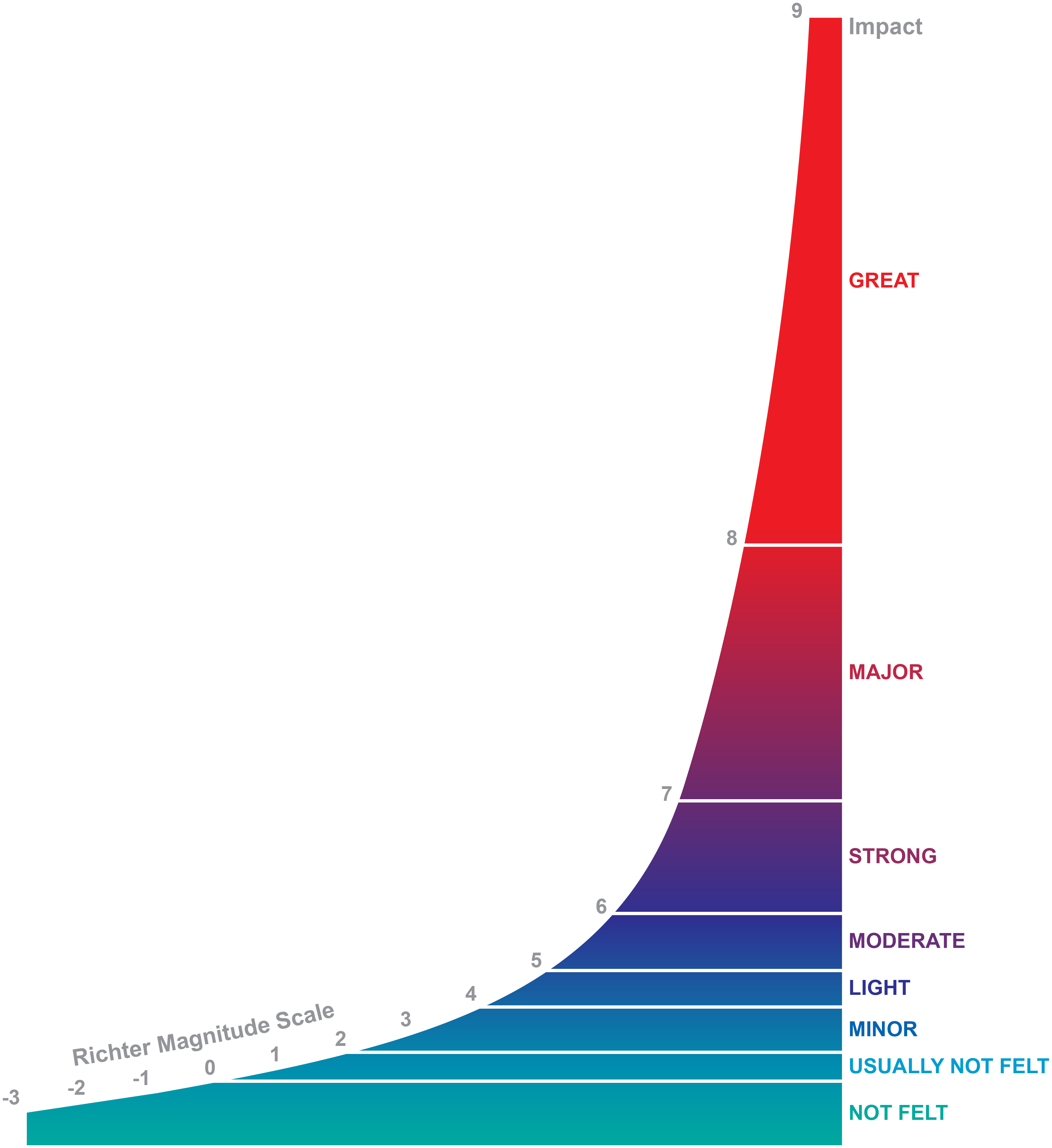
What is an earthquake magnitude?
Magnitude is a measure of earthquake size and is determined from the logarithm of the maximum displacement or amplitude of the earthquake signal as seen on the seismogram, with a correction for the distance between the focus and the seismometer. This is necessary as the closer the seismometer is to the earthquake, the larger the amplitude on the seismogram, irrespective of the size or magnitude of the event. Since the measurement can be made from P, S or surface waves, several different scales exist, all of which are logarithmic because of the large range of earthquake energies (for example a magnitude 6 ML is 30 times larger, in terms of energy than a magnitude 5 ML). The Richter local magnitude (ML) is defined to be used for earthquakes up to 600km away, and is the magnitude scale used by BGS when locating UK Earthquakes. Standard practice in earthquake seismology is to calculate the magnitude to one decimal place.
How can earthquake magnitudes be negative?
Magnitude scales are logarithmic. This means that the amplitude recorded must decrease 10 times for the magnitude to decrease by 1 unit.
At a station close to a magnitude 2 earthquake, the ground moves about 400 micrometres. So a ground movement of 40 micrometres would signify a magnitude 1 earthquakes, 4 micrometres a magnitude 0 earthquakes and 0.4 micrometres a magnitude -1 earthquake.
Earthquakes with negative earthquakes are never felt at the surface.
What is a felt report?
What people feel or experience during an earthquake can be used to estimate the intensity of ground shaking in different places, as a result, it is possible to use people as "intensity sensors" and collect earthquake felt reports for significant earthquakes. BGS collects felt reports through an online earthquake questionnaire. These reports are analysed and quality assessed by our seismic experts.
What is earthquake intensity?
Magnitude is a measure of earthquake size and remains unchanged with distance from the earthquake. Intensity, however, describes the degree of shaking caused by an earthquake at a given place and decreases with distance from the earthquake epicentre. Magnitude measurement requires instrumental monitoring for its calculation, however, assigning an intensity requires a sample of the felt responses of the population. This is then graded according to the European Macroseismic Scale, (Grunthal,1998). For example, Intensity 1, Not felt, 2, Scarcely perceptible, 3, weak, felt by a few, up to 12 assigned for total devastation. More information: intensity table
Why are the events listed on the Recent Events list not visible on the Real Time Seismograms?
The events are very small, much smaller that we would normally be able to detect. Each horizontal line on the real time seismogram shows 30 minutes of data.
Why does hydraulic fracturing cause seismicity?
The injection of high pressure fluid into intact rock generates cracks. The cracks grow as a result of tiny seismic events at the tips. This process increases the permeability of the rock, allowing trapped gas to be extracted. These events are often referred to as induced and the energy for them is limited by the amount of energy in the injection process. This means the magnitudes are generally small.
What other activities can induce earthquakes?
Activities such as underground mining, impoundment of deep artificial water reservoirs, oil and gas extraction, geothermal power generation, waste water disposal in deep wells and groundwater abstraction have all resulted in cases of induced seismicity. In addition, activities such as blasting during quarry operations can also result ground vibrations that are comparable to small earthquakes.
Tremors in the coalfields of Britain have been reported for at least the last hundred years, and work by the BGS and others led to the conclusion that these events were related to ongoing mining activity and that these were quite distinct from the natural background seismic activity of the UK.

- BGS Environmental Baseline Monitoring
- Government guidance on fracking: developing shale oil and gas in the UK
- Royal Society and Royal Academy of Engineering review of the risks associated with hydraulic fracturing during shale gas exploration and production
- National Research Council, 2012. Induced seismicity potential in energy technologies, National Academies Press
- Seismological Research Letters: Special Issue on Injection-Induced Seismicity.
- British Geological Survey Shale Gas Project