Summary
| DATE | 07/06/1931 |
| ORIGIN TIME | 00:25:00 UTC |
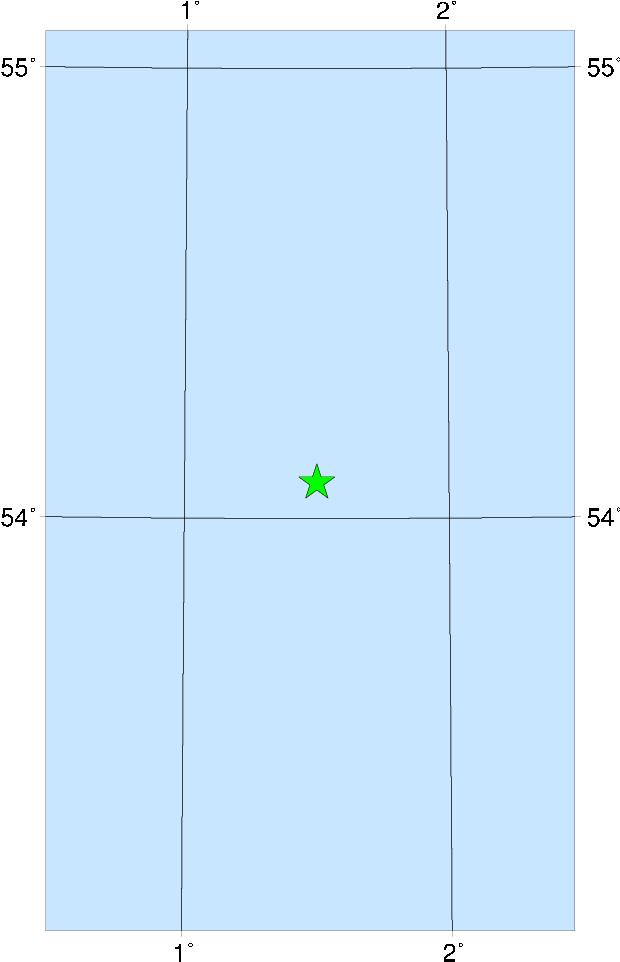
| LOCATION | 54.080 1.500 |
| DEPTH | 23.0 km |
| MAGNITUDE | 6.1 ML |
| LOCALITY | NORTH SEA |
| DATE | 07/06/1931 |
| ORIGIN TIME | 00:25:00 UTC |
| LOCATION | 54.080 1.500 |
| DEPTH | 23.0 km |
| MAGNITUDE | 6.1 ML |
| LOCALITY | NORTH SEA |

This is the largest UK earthquake for which a magnitude can be calculated or reliably estimated; it is thus rather fortunate that the epicentre was offshore in the Dogger Bank area. The felt area encompassed virtually the whole of Great Britain, the E of Ireland (there is anecdotal evidence of it being felt as far west as Londonderry), N France, Belgium, the Netherlands, parts of NW Germany, Denmark and SW Norway. The outer limits might be better determined had the event not happened in the middle of the night. Damage in Britain was reported from 71 different places, mostly along the E coast of England. The strongest effects were observed at Filey, Bridlington, Beverley and Hull. The top of a church spire was rotated at Filey. Although there were numbers of cases of chimneys and plaster being damaged, at no place were the effects sufficiently severe to be assessed unequivocably as 7 MSK. Slight damage was caused as far afield as Sudbury, Suffolk, Barnsley, Yorks. and Wooler, Northumberland. The complete collapse of a factory roof at Staines (Surrey) was attributed to the earthquake, though there is some doubt on this issue.
There were some geotechnical observations: rocks fell from the cliffs at Flamborough Head and there were falls of cliff at Mundesley, Norfolk. There were also some curious reports of lights seen in the sky at the time of the shock. The shock was reported as being felt on board ship by a number of vessels in the N Sea.
One woman in Hull seems to have died of a heart attack as a result of the earthquake.
Sources: Neilson et al (1986), instrumental.