Summary
| DATE | 02/11/1893 |
| ORIGIN TIME | 17:45:00 UTC |
| LOCATION | 51.810 -4.410 |
| DEPTH | 24.0 km |
| MAGNITUDE | 5.0 ML |
| LOCALITY | CARMARTHEN |
| DATE | 02/11/1893 |
| ORIGIN TIME | 17:45:00 UTC |
| LOCATION | 51.810 -4.410 |
| DEPTH | 24.0 km |
| MAGNITUDE | 5.0 ML |
| LOCALITY | CARMARTHEN |
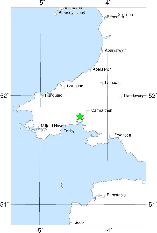

Just over a year after the 1892 Pembroke earthquake, an event of similar size occurred with an epicentre just SW of Carmarthen, only about 25 km E of the 1892 epicentre. Curiously, while the effects of the 1892 earthquake were felt most strongly to the south, those of the 1893 event were much stronger to the north, suggesting a different pattern of energy radiation and thus different focal mechanisms.
Again, damage was slight. A few chimneys were damaged and some plaster fell, the area of damage extending from Cardigan to Swansea, with one isolated damage report outside this area (Ironbridge, Shrops.). There was no damage at Carmarthen itself. The waters of the Towy estuary were disturbed by the shock.
The limits of the felt area are: north - near Lancaster; east - near Market Harborough plus an isolated report from London; south - Gunnislake on the Cornwall/Devon border; west - Tullow, Ireland.
Sources: Musson et al (1984a).